The Utah Geo-Health Lab was established in 2014. Research of the lab focuses on using GIS and spatial methods to investigate public health and environmental health problems. Current projects of the lab include smartphone-based mobility study, access to healthcare, neighborhood context analysis of health behaviors, GIS-assisted air pollution exposure modeling, health consequences of agricultural pesticides exposure, and health disparities. Details of these projects are below.
Projects
Smartphone-based mobility research
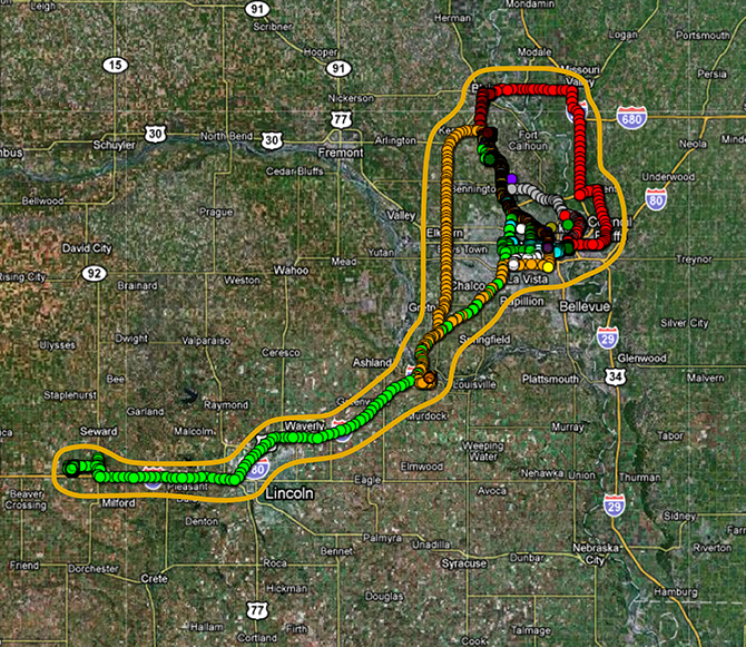
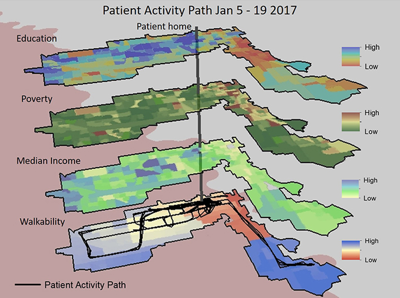
Aging is a global challenge that faces not only the United States but also a lot of other countries. How to maintain the health status of the aging population and how to efficiently utilize healthcare resources have become important tasks for health professionals. Smartphones, which come with GPS, accelerometer, and other inertial sensors, provide an innovative way of tracking the health status of older adults while minimizing their burdens of data collection.
This project adopts the concept of “life-space” to measure older adults’ functional status and mobility. Specifically, it estimates the location, duration, and physical intensity information of activities from the phone collected GPS, Bluetooth, and accelerometer data. Such information is then integrated to generate life-space indicators that are potentially useful in clinical settings. The template of smart-phone data collection and processing will not only directly benefit geriatric studies, but will also facilitate the understanding of individuals’ spatial behaviors in various environmental health studies such as air pollution exposure.
Health consequences of exposure to agricultural pesticides
 The extensive application of pesticides in modern agriculture has led to growing concerns
about their adverse consequences to the environment and population health. Exposure
to agricultural pesticides has been linked with various health problems such as cancer,
neuro-degenerative diseases, and human reproductive problems. However, such studies
are generally limited by inadequate measurement of pesticide exposure and small patient
cohorts.
The extensive application of pesticides in modern agriculture has led to growing concerns
about their adverse consequences to the environment and population health. Exposure
to agricultural pesticides has been linked with various health problems such as cancer,
neuro-degenerative diseases, and human reproductive problems. However, such studies
are generally limited by inadequate measurement of pesticide exposure and small patient
cohorts.
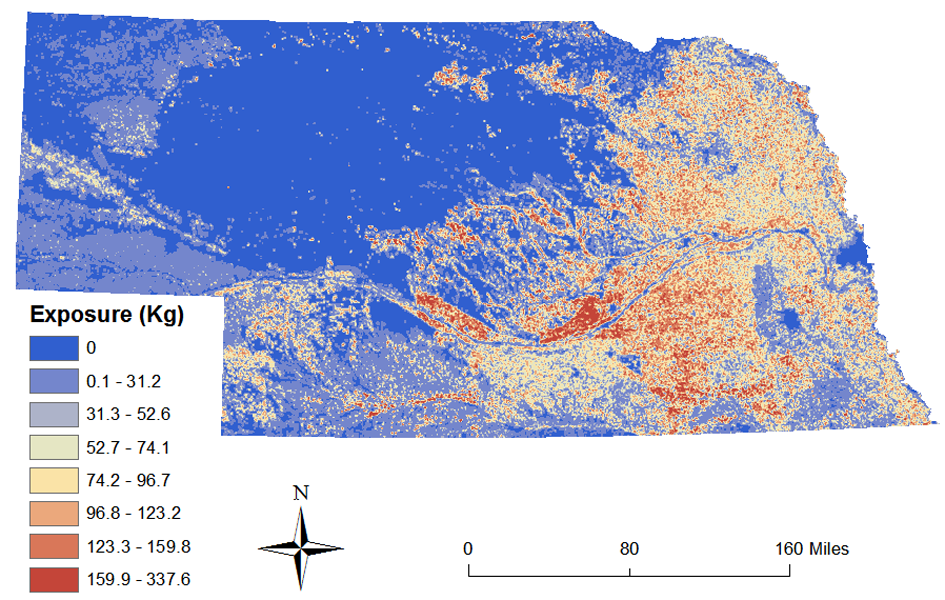
This project utilizes GIS, remote sensing-derived land use information, and grid-based population data to examine population exposure to agricultural pesticides at high spatial resolutions in Nebraska. Such exposure information is then linked with state level disease registries to explore health consequences of the exposure. The long-term goal of this project is to build an environmental data infrastructure that could facilitate environment-health studies in agricultural states.
Access to Healthcare
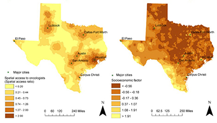 Access to healthcare refers to a person’s ease of obtaining healthcare services that
can bring about the best possible health outcome. Access to health services can be
classified into spatial and non-spatial access based on how the accessibility is influenced
by spatial factors (for example, spatial location and travel distance) and non-spatial
factors (for example, Socioeconomic Status (SES), health insurance status, and cultural
background). This project focuses on utilizing GIS to model access to medical services
such as primary care, oncologist care, and emergency general surgery, and to understand
the geographic and socio-demographic patterns of the access. The study sites include
Texas, Nebraska, California, Utah, and the whole United States.
Access to healthcare refers to a person’s ease of obtaining healthcare services that
can bring about the best possible health outcome. Access to health services can be
classified into spatial and non-spatial access based on how the accessibility is influenced
by spatial factors (for example, spatial location and travel distance) and non-spatial
factors (for example, Socioeconomic Status (SES), health insurance status, and cultural
background). This project focuses on utilizing GIS to model access to medical services
such as primary care, oncologist care, and emergency general surgery, and to understand
the geographic and socio-demographic patterns of the access. The study sites include
Texas, Nebraska, California, Utah, and the whole United States.
Health Disparities
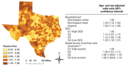 Health disparity refers to an inequality in which disadvantaged people systematically
suffer worse health and less access to health care than advantaged people. Disadvantaged
social groups can be characterized by race/ethnicity, SES (e.g., income, education,
poverty status), geographic location, age, disability, and sexual orientation. Understanding
how health outcomes vary among different social groups is an important prerequisite
for reducing these disparities. This project uses GIS and spatial statistical methods
to investigate geographic, socioeconomic, and racial/ethnic disparities in cancer
outcomes such as late-stage diagnosis, survival, and mortality. It also explores how
these disparities are related with access to cancer prevention and treatment.
Health disparity refers to an inequality in which disadvantaged people systematically
suffer worse health and less access to health care than advantaged people. Disadvantaged
social groups can be characterized by race/ethnicity, SES (e.g., income, education,
poverty status), geographic location, age, disability, and sexual orientation. Understanding
how health outcomes vary among different social groups is an important prerequisite
for reducing these disparities. This project uses GIS and spatial statistical methods
to investigate geographic, socioeconomic, and racial/ethnic disparities in cancer
outcomes such as late-stage diagnosis, survival, and mortality. It also explores how
these disparities are related with access to cancer prevention and treatment.
Neighborhood Contexts of Health Behaviors
 Various theories and models, including social cognitive theory and social ecological
models, have been adopted to model the individuals’ health behaviors. Generally, these
models posit that an individual’s health behavior is influenced by multilevel factors
including intrapersonal, interpersonal, neighborhood environmental (both built and
social), and policy variables and thus individuals cannot be adequately studied without
a consideration of the multiple ecological systems in which they live. My research
on the influence of neighborhood environments on health behaviors has focused on studying
how an individual’s dynamic exposure to neighborhood factors may influence subsequent
behaviors such as smoking. This differs from traditional, static definition of neighborhood
contexts by using individual trajectory data and high-resolution GIS data to model
individuals’ exposures. In addition, taking advantage of mobile health technologies,
I also study how intrapersonal and self-regulatory factors (e.g., stress, negative
affect) may mediate or moderate the relationship between neighborhood context and
health behaviors.
Various theories and models, including social cognitive theory and social ecological
models, have been adopted to model the individuals’ health behaviors. Generally, these
models posit that an individual’s health behavior is influenced by multilevel factors
including intrapersonal, interpersonal, neighborhood environmental (both built and
social), and policy variables and thus individuals cannot be adequately studied without
a consideration of the multiple ecological systems in which they live. My research
on the influence of neighborhood environments on health behaviors has focused on studying
how an individual’s dynamic exposure to neighborhood factors may influence subsequent
behaviors such as smoking. This differs from traditional, static definition of neighborhood
contexts by using individual trajectory data and high-resolution GIS data to model
individuals’ exposures. In addition, taking advantage of mobile health technologies,
I also study how intrapersonal and self-regulatory factors (e.g., stress, negative
affect) may mediate or moderate the relationship between neighborhood context and
health behaviors.
People
UGHL is looking for talented and self-motivated students, both undergraduate and graduate, to work on quality research in the broad field of Health Geography. If you are interested in discussing a potential topic in Health Geography, please feel free to contact Dr. Neng Wan at neng.wan@utah.edu.
Faculty
Dr. Neng Wan, PhD.
 Neng is an Associate Professor of Geography and the director of the Utah Geo-Health
Lab. His research and teaching interests lie in the intersection between health geography
and geographic information science (GIScience). Geography, especially GIScience, is
playing an ever more important role in medical/health research. His major motivation
of research and teaching is to advance knowledge in this relatively new field and
provide excellent educational experience to students.
Neng is an Associate Professor of Geography and the director of the Utah Geo-Health
Lab. His research and teaching interests lie in the intersection between health geography
and geographic information science (GIScience). Geography, especially GIScience, is
playing an ever more important role in medical/health research. His major motivation
of research and teaching is to advance knowledge in this relatively new field and
provide excellent educational experience to students.
Students
Rebecca Richards-Steed
 Rebecca is a PhD student in Health Geography. She studies transgenerational environmental
exposure and familial disease patterns. Her current research focuses on Autism Spectrum
Disorder spatial-temporal patterns across and between families with the shared disease
outcome. She is a frequent speaker at conferences and presented at TEDx Salt Lake
City in 2017. Rebecca currently works at the Huntsman Cancer Institute, Utah Population
Database as a research assistant. She is also an adjunct professor at Weber State
University, where she teaches advanced GIS.
Rebecca is a PhD student in Health Geography. She studies transgenerational environmental
exposure and familial disease patterns. Her current research focuses on Autism Spectrum
Disorder spatial-temporal patterns across and between families with the shared disease
outcome. She is a frequent speaker at conferences and presented at TEDx Salt Lake
City in 2017. Rebecca currently works at the Huntsman Cancer Institute, Utah Population
Database as a research assistant. She is also an adjunct professor at Weber State
University, where she teaches advanced GIS.
Matt McCullough
 Matt is a PhD candidate in the Department of Geography. He graduated with a Bachelor
of Science in Geography from the U of U in 2005 and went on to earn his masters degree
in Natural Resources from Utah State University in 2011. He has also earned a post-baccalaureate
certificate in GIS from Penn State in 2008 and a Graduate Certificate in Public Health
from the U of U in 2018. Matt worked as the GIS Administrator for Farmington City
for 9 years and he is currently the Director of the Utah Office of Primary Care and
Rural Health at the Utah Department of Health, where he uses his knowledge of geography
and mapping to improve access to primary health care services in rural and underserved
communities in Utah. His PhD research is on The Geography of Type 1 Diabetes in Utah: A Spatial, Temporal and Multilevel Analysis. Matt believes in the saying that "Geography is Destiny in Medicine" and hopes that
his research will further the use of geospatial analysis in healthcare and health
research.
Matt is a PhD candidate in the Department of Geography. He graduated with a Bachelor
of Science in Geography from the U of U in 2005 and went on to earn his masters degree
in Natural Resources from Utah State University in 2011. He has also earned a post-baccalaureate
certificate in GIS from Penn State in 2008 and a Graduate Certificate in Public Health
from the U of U in 2018. Matt worked as the GIS Administrator for Farmington City
for 9 years and he is currently the Director of the Utah Office of Primary Care and
Rural Health at the Utah Department of Health, where he uses his knowledge of geography
and mapping to improve access to primary health care services in rural and underserved
communities in Utah. His PhD research is on The Geography of Type 1 Diabetes in Utah: A Spatial, Temporal and Multilevel Analysis. Matt believes in the saying that "Geography is Destiny in Medicine" and hopes that
his research will further the use of geospatial analysis in healthcare and health
research.
Andrea Davis
 I was born and raised in Utah and never see myself living far from the mountains.
I currently live in Syracuse with my husband, Mason, five-year-old daughter, Millie,
and two cattle dogs, August and Von. In addition to school and being a mother, I work
as a long lens photographer for chariot and flat track horse racing and have done
so for the last 13 years. While working and learning alongside diverse peers, I have
had the opportunity to be a teaching, research, and graduate assistant during varies
parts of my graduate adventure. One of my most recent research experiences was participating
in a learning abroad focused on antibiotic resistance in Ghana. I am always looking
for different ways to become involved in the community by volunteering with various
organizations and participating in varies research surrounding health. I am currently
focused on integrating my understanding of human health and my passion for geography
to complete my PhD in Geography.
I was born and raised in Utah and never see myself living far from the mountains.
I currently live in Syracuse with my husband, Mason, five-year-old daughter, Millie,
and two cattle dogs, August and Von. In addition to school and being a mother, I work
as a long lens photographer for chariot and flat track horse racing and have done
so for the last 13 years. While working and learning alongside diverse peers, I have
had the opportunity to be a teaching, research, and graduate assistant during varies
parts of my graduate adventure. One of my most recent research experiences was participating
in a learning abroad focused on antibiotic resistance in Ghana. I am always looking
for different ways to become involved in the community by volunteering with various
organizations and participating in varies research surrounding health. I am currently
focused on integrating my understanding of human health and my passion for geography
to complete my PhD in Geography.
Jiuying Han
 Jiuying Han is a Ph.D. student and UGHL Research Assistant. Her current research focuses
on spatial accessibility to healthcare facilities, hospital bypass behavior, and the
relationship between urban green space and disease. Jiuying enjoys living in Salt
Lake City for its abundant opportunities for outdoor adventures. She loves the U of
U, where she has found amazing friends and professors. Jiuying is looking forward
to the adventures her academic career will bring and her contributions to the field
of Health Geography her research will provide.
Jiuying Han is a Ph.D. student and UGHL Research Assistant. Her current research focuses
on spatial accessibility to healthcare facilities, hospital bypass behavior, and the
relationship between urban green space and disease. Jiuying enjoys living in Salt
Lake City for its abundant opportunities for outdoor adventures. She loves the U of
U, where she has found amazing friends and professors. Jiuying is looking forward
to the adventures her academic career will bring and her contributions to the field
of Health Geography her research will provide.
Steven Lizotte
 Steve is a Master of Science student and Research Assistant in the Department of Geography.
Steve graduated with a Bachelor of Science in Geography from the University of Utah
in May of 2016 and an Associate of Applied Science in Geospatial Technology from Salt
Lake Community College in May of 2015. His current research focus in Health Geography
involves the distribution of crime and the relationship of that distribution at scale
to macro-level predictors of criminogenesis in Salt Lake County Utah. Additionally,
Steve is contributing to work on the health outcomes of tobacco and alcohol use and
cessation in Harris County Texas in collaboration with researchers from the University
of Memphis.
Steve is a Master of Science student and Research Assistant in the Department of Geography.
Steve graduated with a Bachelor of Science in Geography from the University of Utah
in May of 2016 and an Associate of Applied Science in Geospatial Technology from Salt
Lake Community College in May of 2015. His current research focus in Health Geography
involves the distribution of crime and the relationship of that distribution at scale
to macro-level predictors of criminogenesis in Salt Lake County Utah. Additionally,
Steve is contributing to work on the health outcomes of tobacco and alcohol use and
cessation in Harris County Texas in collaboration with researchers from the University
of Memphis.
Alumni
Dapeng Li
 I am an Assistant Professor of GIS in the Department of Geography at South Dakota
State University. As a well-trained GIScientist, I am teaching introductory and upper-level
GIS courses and developing some new GIS courses to further improve our GIS curriculum
at SDSU. My current research primarily focuses on wildfire evacuation modeling and
simulation in the American west. Meanwhile, I also start to work on other topics in
hazards, public health, transportation, and sustainability.
I am an Assistant Professor of GIS in the Department of Geography at South Dakota
State University. As a well-trained GIScientist, I am teaching introductory and upper-level
GIS courses and developing some new GIS courses to further improve our GIS curriculum
at SDSU. My current research primarily focuses on wildfire evacuation modeling and
simulation in the American west. Meanwhile, I also start to work on other topics in
hazards, public health, transportation, and sustainability.
PUblications
Lin, Y., Wan, N., Sheets, R., Gong, X., A, Davies. 2018. A Multi-modal Relative Spatial Access Assessment Approach to Measure Spatial Accessibility to Primary Care Providers. International Journal of Health Geographics 17:33
Wan, N., M, Wen., J, Fan., F, Tavake-Pasi., S, McCormick., K, Elliott., E, Nicolosi. 2018. Physical Activity Barriers and Facilitators among U.S. Pacific Islanders and the Feasibility of Using Mobile Technologies for Intervention: A Focus Group Study with Tongan Americans. Journal of Physical Activity and Health 15(4): 287-294
Wan, N., Siahpush, M., Shaikh, RA., McCarthy, M., Ramos, A., and Correa, A. 2018. The association of point-of-sale e-cigarette advertising with socio-demographic characteristics of neighborhoods. Journal of Primary Prevention 39(3): 191-203
Wang, H., Gregg, A., Qiu, F., Kim, J., Chen, B., Su, D., Michaud, T., Wan, N., Chen, L. 2018. Breast cancer screening for patients of rural Accountable Care Organization clinics: A multi-level analysis of barriers and facilitators. Journal of Community Health 43(2): 248-258
Wan, N., Siahpush, M., Shaikh, RA., McCarthy, M., Ramos, A., and Correa, A. 2018. Point-of-sale E-cigarette Advertising among Tobacco Stores. Journal of Community Health 42(6):1179-1186
Wan, N & G. Lin. 2017. Addressing Location Uncertainties in GPS-based Activity Monitoring: a Methodological Framework. Transactions in GIS. 21(4): 764-781
Fan, J., Wen, M., and Wan, N. Built Environment and Active Commuting: Rural-Urban Differences in the U.S. SSM – Population Health 3: 435-441
Wang, H., Qiu, F., Gregg, A., Chen, B., Kim, J., Young, L,. Wan, N., and Chen, L. 2017. Barriers and Facilitators of Colorectal Cancer Screening for Patients of Rural Accountable Care Organizations Clinics: A Multi-Level Analysis. Journal of Rural Health 34(2):202-212
Siahpush, M., Shaikh, R. A., Wan, N., et al. 2017. Neighborhood exposure to point-of-sale price promotions for cigarette is associated with financial stress among smokers: Results from a population-based study. Tobacco Control 26: 703-708
Wen, M., Fan, J., Kowaleski-Jones, L., and N, Wan. 2017. Rural-urban Disparities in Overweight and Obesity among Working Age Adults in the United States: Patterns and Mechanisms. American Journal of Health Promotion 32(2): 400-408
Lin, Y., Wan, N., FB Zhan. 2017. Colorectal cancer disparities among racial/ethnic minorities in Texas. Annals of GIS 23(2): 93-101.
Wan, N & G. Lin. 2016. Classifying Human Activity Patterns from Smartphone Collected GPS data: A Fuzzy Classification and Aggregation Approach. Transactions in GIS. 20(6): 869-886
Zhai, L., Zou, B., Fang, X., Luo, Y., Wan, N., S, Li. 2016. Land Use Regression Modeling of PM2.5 Concentrations at Optimized Spatial Scales. Atmosphere 8 (1), 1
Zou, B., Zheng, Z., Wan, N., Qiu, Y., and J.G. Wilson. 2016. An optimized spatial proximity model for fine particulate matter air pollution exposure assessment in areas of sparse monitoring. International Journal of Geographical Information Science 30 (4), 727-747
Wan, N & G. Lin. 2016. Parkinson’s Disease and Pesticides Exposure: New Findings from a Comprehensive Study in Nebraska, USA. Journal of Rural Health 32(3): 303-313.
Wan, N. 2015. Pesticides exposure modeling based on GIS and remote sensing land use data. Applied Geography 56: 99-106.
Siahpush, M., Shaikh, R. A., Hyland, A., Smith, D., Sikora Kessler, A., Meza, J., Wan, N & Wakefield, M. 2015. Point-of-sale cigarette marketing, urge to buy cigarettes, and unplanned purchases of cigarettes: Results from a population-based survey. Nicotine and Tobacco Research 16: 302
Siahpush, M., Shaikh, R.A., Cummings, K.M., Hyland, A., Dodd, M., Carlson, L., Kessler, A. S., Meza, J., Wan, N., Wakefield, M. 2015. The association of point-of-sale cigarette marketing with cravings to smoke: results from a cross-sectional population-based study. Tobacco Control: doi:10.1136/tobaccocontrol-2015-052253
Zou, B., Luo, Y., Wan, N., Zheng, Z., Sternberg, T., and Liao, Y. 2015. Performance comparison of LUR and OK in PM2.5 concentration mapping: a multidimensional perspective. Scientific Reports 5: 8698
Zou, B., Wang, M., Wan, N., J, Wilson., X, Fang., and Y, Tang. 2015. Spatial modeling of PM2. 5 concentrations with a multifactoral radial basis function neural network. Environmental Science and Pollution Research 22 (14), 10395-10404
Zou, B., Peng, F., Wan, N., Mamady, K., and Wilson, J. 2014. Spatial cluster detection of air pollution exposure inequality in the United States. PLOS ONE 9 (3)
Zou, B., Peng, F., Wan, N., Wilson, J. 2014. Sulfur dioxide exposure and environmental justice: a multi-scale and source-specific perspective. Atmospheric Pollution Research 5: 491-499.
Dong, M., Zou, B., Pu, Qian., Wan, N., Yang, L., Luo, Y. 2014. Spatial pattern evolution and causal analysis of county level economy in Chang-Zhu-Tan urban agglomeration, China. Chinese Geographical Science 24(5): 620-630.
Wan, N. & G Lin. 2013. Life-space characterization from cellular telephone collected GPS data. Computers, Environment and Urban Systems 39: 63-70.
Wan, N. & G Lin. 2013. Life-space characterization from cellular telephone collected GPS data. Computers, Environment and Urban Systems 39: 63-70.
Wan, N., Qu, W., Whitington, J., Witbrodt, B., Henderson, M., Goulding, E., Schenk, A., Bonasera, S., and Lin, G. 2013. Assessing smart phones for generating life space indicators. Environment and Planning B: Planning and Design 40(2): 350-361.
Wan, N., Zhan, FB., Zou, B., and Wilson, JG. 2013. Spatial access to healthcare services and disparities in colorectal cancer stage at diagnosis in Texas. The Professional Geographer 65(3): 527-541.
Wan, N., Zou, B., Sternberg, T. 2012.A three-step floating catchment area method for analyzing spatial access to health services. International Journal of Geographic Information Science 26(6): 1073-1089.
Wan, N., Zhan, FB., Lu, Y., and Tiefenbacher, J. 2012. Access to health care and disparities in colorectal cancer survival in Texas. Health & Place 18(2): 321-329.
Wan, N., Zhan, FB., Zou, B., and Chow, T. 2012. A relative spatial access assessment approach for analyzing potential spatial access to colorectal cancer services in Texas. Applied Geography 32(2): 291-299.
Wan, N., Zhan, FB., and Cai, Z. 2011. Socioeconomic disparities in prostate cancer mortality and the impact of geographic scale. Southern Medical Journal 104(8): 553-559.
Wan, N., Zhan, FB., and Cai, Z. 2011. A spatially weighted degree model for network vulnerability analysis. Geo-spatial Information and Science 14(4): 274-281.
Courses
GEOG 3090/5090 Introduction to Medical/Health Geography
This course is designed to provide students with a broad introduction to medical geography. Topics include history of medical geography, environments and health, developmental change and human health, diffusion of disease, human modification of the environment and health, inequalities in health outcomes, inequalities in provision and utilization of health care resources, and methods for spatial epidemiology ranging from GIS (Geographic Information Systems)-based visualization to statistical analysis. Selected case studies will be presented in order to illustrate real-world applications of theories, methods, and techniques discussed in class.
GEOG 5190/6190 GIS for Environmental and Public Health
This course covers applications of Geographic Information Systems (GIS) and remote sensing in public health. The course will describe in-depth how GIS and spatial analysis/statistics can be used to map health events, identify disease clusters, assess health services, investigate environmental health problems, and understand the distribution and spread of contagious a vector-borne infectious disease. Additional topics covered include designing effective disease maps, data acquisition, geocoding, accuracy assessment, data confidentiality, and masking health data. Selected case studies will be presented in order to highlight principles, methods, and techniques. Hands-on experience will be gained through laboratory exercises and real-world applications.
GEOG 6090 Topics in Medical/Health Geography
This seminar class is designed to help you get familiar with advanced applications of GIS and spatial methods in medical/health geography. The material covered will center around a unique geographic framework for understanding how the complex interactions among individuals, society, and environment influences population health. More specifically, it will first provide an overview of most common geographic methods utilized in public health and environmental health. Then, selected case studies will be presented in order to highlight principles, methods, and techniques. Relevant topics include health disparity, healthcare accessibility, environmental exposure, and mobile health